


Hurricane Erin 2025: Category 5 Storm Threatens Caribbean, Eyes U.S. Coast
August 17, 2025 – Hurricane Erin, the first major hurricane of the 2025 Atlantic season, has escalated into a dangerous Category 5 storm with sustained winds reaching 160 mph as reported by the National Hurricane Center (NHC) on Saturday, August 16. Forming on August 11 and strengthening into a hurricane by August 15, Erin is currently churning through the Atlantic, impacting parts of the Caribbean and raising alarms for hazardous surf along the U.S. East Coast.
Current Position and Strength
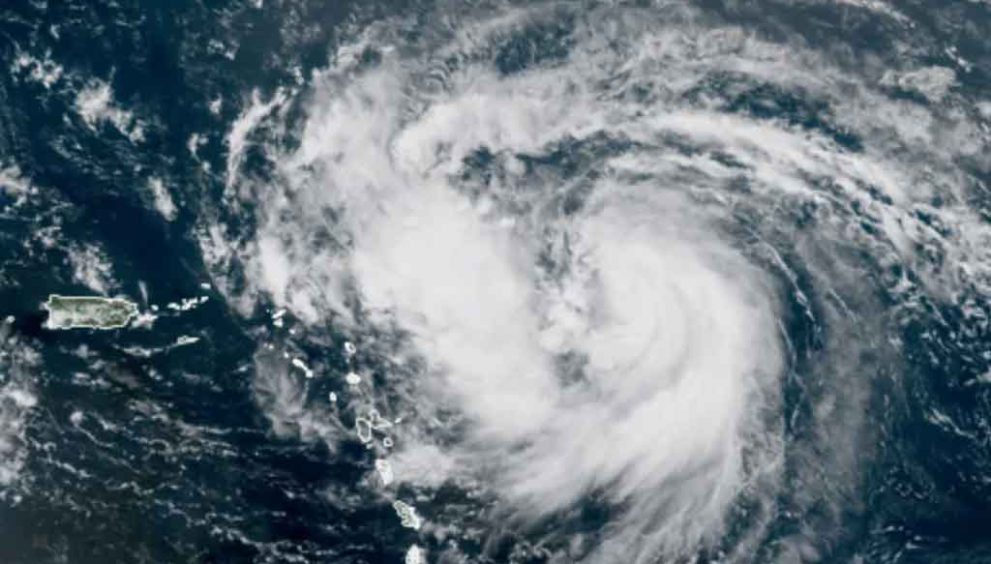
At 5 a.m. AST on August 17, Hurricane Erin was located approximately 135 miles north-northwest of Anguilla, near latitude 20.0 North, longitude 64.0 West, moving west-northwest at 15 mph. With a central pressure of 915 mb, the storm boasts hurricane-force winds extending 30 miles from its center and tropical-storm-force winds stretching up to 160 miles, primarily northward. While Erin briefly weakened to a Category 4 with 150 mph winds late Saturday due to an eyewall replacement cycle, it remains a formidable threat with potential for fluctuations in intensity.
Forecasted Path
According to the NHC, Erin is expected to continue its west-northwest trajectory through Sunday, August 17, passing just north of the northern Leeward Islands, the Virgin Islands, and Puerto Rico. By Sunday night or Monday, the storm will approach the Turks and Caicos Islands and the southeastern Bahamas, staying east of these regions. A northward turn is anticipated early next week, with Erin projected to track between Bermuda and the U.S. East Coast by mid-week, likely avoiding direct landfall on the mainland due to a cold front steering it out to sea.
Caribbean Impacts
Puerto Rico, the U.S. Virgin Islands, and the northern Leeward Islands are already feeling Erin’s outer bands, with 2 to 4 inches of rain expected through Sunday, and isolated areas potentially seeing up to 6 inches. This could trigger flash flooding, urban flooding, and landslides. Gusty winds of 40 to 50 mph are also forecast for these areas. Tropical storm watches are in place for St. Martin, St. Barthelemy, Sint Maarten, Anguilla, Barbuda, and the Turks and Caicos Islands, where tropical storm conditions may occur within the next 12 to 48 hours. Residents are urged to stay vigilant and monitor local weather updates.
U.S. East Coast Concerns
While Erin is expected to remain offshore, its effects will reach the U.S. East Coast from August 20 to 27. The NHC warns of life-threatening surf and rip currents, with waves of 8 to 12 feet possible along North Carolina’s Outer Banks and 6 feet in parts of South Carolina and Virginia. Florida’s Atlantic coast, including Jacksonville, could see breakers exceeding 7 feet on August 19 and 20. Bermuda may also experience strong winds and heavy rainfall by mid-week, prompting close monitoring.
Erin’s Intensity and Significance
Erin’s rapid intensification from a 75-mph tropical storm on August 15 to a Category 5 hurricane within 24 hours marks it as one of the most powerful early-season storms on record. Its “stadium effect” eyewall, observed by the 53rd Weather Reconnaissance Squadron, highlights its strength. Although it weakened slightly to Category 4, the NHC predicts Erin may maintain major hurricane status (Category 3 or higher) through Monday, with a gradual decline to 115 mph by Thursday, August 21.
The Saffir-Simpson Hurricane Wind Scale categorizes hurricanes as:
- Category 1: 74–95 mph
- Category 2: 96–110 mph
- Category 3: 111–129 mph
- Category 4: 130–156 mph
- Category 5: 157 mph or higher
Erin’s Category 5 status underscores its potential for catastrophic damage if it were to make landfall.
2025 Hurricane Season Context
The 2025 Atlantic hurricane season, spanning June 1 to November 30, is expected to be above average, with NOAA predicting 14 named storms, seven hurricanes, and three major hurricanes. Erin, the fifth named storm after Andrea, Barry, Chantal, and Dexter, signals the start of the season’s peak, which runs from mid-August to mid-October, with September 10 as the statistical peak.
Safety Recommendations
Residents in the Caribbean, particularly in Puerto Rico and the Virgin Islands, should prepare for heavy rain and strong winds, ensuring emergency supplies are ready. Those along the U.S. East Coast should avoid beaches due to dangerous surf conditions. Florida residents are encouraged to maintain hurricane kits, with tax-free supplies like batteries and generators available year-round. For real-time updates, visit the NHC at www.nhc.noaa.gov or follow local weather services like www.weather.com.
Hurricane Erin serves as a stark reminder of the 2025 season’s potential. Stay informed and prepared as this powerful storm continues its path through the Atlantic.
Sources: National Hurricane Center, ABC News, USA TODAY, FOX 35 Orlando