


US Weather Alert Feb 2026: Storms, Northeast Thaw & Rain
US Weather Alert Feb 2026: Storms, Northeast Thaw & Rain
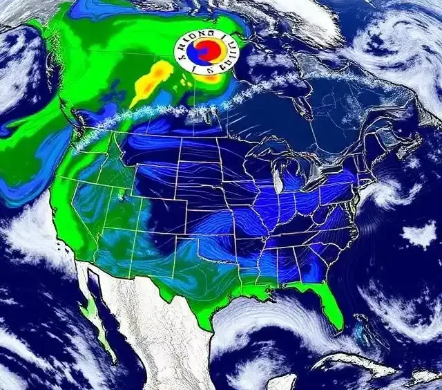
As of February 10, 2026, a significant shift in the upper-level weather pattern is underway across the United States, driven by a large dip (trough) in the jet stream parking over the Western U.S. This reversal from the recent dominant pattern ends prolonged record warmth in parts of the West, persistent dryness in California, and Arctic cold locked over the East. Forecasters from the National Weather Service (NWS), NOAA Climate Prediction Center (CPC), FOX Weather, and AccuWeather describe it as a “major pattern change” that will promote active storm tracks, increased precipitation risks, and temperature swings through late February.
The Jet Stream Shift: What’s Driving the Change?
The jet stream—a high-altitude river of fast-moving air—has been influenced by factors including a weakening La Niña transitioning toward neutral conditions, Madden-Julian Oscillation (MJO) activity, and stratospheric influences. A deep trough is now stalling over the West Coast and extending into the Southwest, allowing moisture-laden systems to originate in the Pacific and track eastward across the country.
- This promotes a ridge of high pressure building over the East, shielding much of the region from the deepest Arctic air.
- On the flip side, the Western dip energizes storm formation, pulling subtropical moisture northward and setting up potential for severe weather, heavy rain, snow, and cross-country systems.
NOAA’s CPC highlights increased hazardous weather risks over the western half of the U.S., with above-normal precipitation favored in many areas after a drier January-early February.
Regional Breakdowns & Key Threats
California & West Coast (Atmospheric Rivers & Heavy Rain/Snow Risks):
- A series of systems, including “atmospheric rivers” (narrow bands of concentrated moisture), are forecast to impact the region starting mid-to-late next week.
- Weak but coherent storms begin landing in central California mid-week (around February 11–12), bringing bursts of rainfall statewide and snowfall at higher elevations (Sierra Nevada, Cascades).
- A “major pattern change” ramps up from Saturday night (February 14–15 onward), with multiple heavy, colder storm rounds possible through late February. High risks for heavy precipitation are noted in coastal areas (San Francisco, Los Angeles, San Diego) around February 17, with moderate risks extending into southwestern Oregon and the Pacific Northwest later.
- Snow levels could drop to 5,000 feet in some events, benefiting snow-starved mountains but raising flash flood/urban flooding concerns in lowlands if rain is heavy.
- This revives winter after unseasonable warmth and dryness—welcome for reservoirs and ski areas, but watch for mudslides in burn scar areas.
Northeast & East (Thaw After Arctic Blast):
- After weeks of polar vortex-driven frigid air, hazardous cold, and snow, a gradual thaw is on the way.
- Temperatures rise into the 40s (and higher in some spots) from mid-next week (around February 11–15), with muted warming compared to the South/Central U.S.
- A potential cross-country storm could track through the Midwest into the Northeast, bringing wintry mix, rain, or even significant snow if the system taps residual cold air—scenarios vary from impactful snow to milder rain.
- Gradual warming is preferred to avoid rapid ice/snow melt leading to flooding (lessons from past events like 1996). High winds and mixed precipitation remain possible in transitional zones.
Nationwide Severe Storm Potential:
- The shifting jet stream opens doors for severe weather, especially in the South/Central U.S., with early-season setups (Gulf moisture plumes) favoring thunderstorms, hail, or tornado risks from Texas to Florida—typical mid-February activity.
- Cross-country threats include heavy precipitation, high winds, and hazardous cold in parts, per NWS hazards outlooks valid through mid-February.
- Southern stream storm tracks could produce Nor’easter-like systems or blizzards in the Plains/Midwest if models align.
Safety Advice & Preparation Tips
- Monitor alerts → Check NWS local forecasts, NOAA Weather Radio, or apps for watches/warnings (e.g., flash flood, winter storm, severe thunderstorm).
- Flooding risks → Avoid flooded roads; California residents in low-lying or burn-scar areas should prepare sandbags and evacuation plans.
- Winter driving → If snow/ice returns in the Northeast or mountains, use chains, reduce speed, and keep emergency kits (blankets, food, water).
- Power outages → Charge devices, have generators safely ready, and know carbon monoxide risks.
- Stay informed → Pattern changes can evolve; follow updates from NWS, FOX Weather, AccuWeather, or CPC.
This active, transitional pattern could bring much-needed moisture to drought-affected West while easing Eastern cold—but with hazards like flooding, severe storms, and variable wintry weather. Climatologically, February often sees such flips as La Niña weakens.
By Certified Meteorologist & Weather Analyst
For more USA news check:
https://clickusanews.com/news/
Latest USA breaking news, national headlines, global affairs, and trending stories.
https://clickusanews.com/sports/
USA sports news, live scores, match highlights, athlete updates, and major sporting events.
https://clickusanews.com/technology/
Technology news covering AI, gadgets, innovation, cybersecurity, and digital trends in the USA.
https://clickusanews.com/entertainment-movies-ott/
Entertainment updates including movies, OTT releases, celebrity news, and pop culture stories.
https://clickusanews.com/business/
Business and finance news with USA market updates, corporate stories, crypto, and economic insights