


Northeast Winter Storm Devin Wreaks Havoc on December
Northeast Winter Storm Devin Wreaks Havoc on December
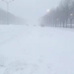
Winter Storm Devin is unleashing its full fury across the Northeast today, dumping 3–8 inches of snow (with isolated pockets up to 12–15 inches in higher terrain) from New York City to parts of New England. Post-Christmas travel is turning treacherous, with winter storm warnings in effect, flight delays piling up, and roads becoming skating rinks—here’s the real-time breakdown of what’s happening right now and how to survive it.
December 26, 2025 – You planned a smooth post-holiday return home. Maybe a quick drive back from family, or a flight out of JFK or Newark to kick off the new week. Instead, Winter Storm Devin decided to crash the party.
This fast-moving but powerful system—named Devin by meteorologists—is tapping into fresh Arctic air and just enough Atlantic moisture to deliver the Northeast’s first major accumulating snowfall in years. It’s not just a dusting: we’re talking shovel-worthy, plow-required accumulations across major metro areas, with the heaviest bands targeting interior regions like the Catskills, northeastern Pennsylvania, and parts of Upstate New York.
As of this morning on December 26, snow is already falling steadily in many spots, with the worst yet to come through Friday evening into Saturday morning. The National Weather Service (NWS) has winter storm warnings blazing from southern Connecticut through northeast New Jersey, southeast New York, and beyond. Millions are affected—15 million at minimum—and the timing couldn’t be worse for the millions wrapping up holiday travel.
Current Conditions and What’s Falling Right Now
Right now, temperatures are hovering in the low to mid-20s across the region, cold enough to keep everything sticking. In New York City, flurries are giving way to steadier snow, with visibility dropping and roads starting to slick over.
WintryMix
26
°
New York·5:48 am
69%
10 mph
Feels like 12°
12 am
28°
1 am
27°
2 am
26°
3 am
25°
4 am
24°
5 am
22°
Now
21°
7:18 am
Sunrise
8 am
21°
9 am
22°
10 am
24°
11 am
26°
12 pm
28°
1 pm
28°
2 pm
29°
3 pm
29°
4:35 pm
Sunset
5 pm
29°
6 pm
29°
7 pm
60%
28°
8 pm
70%
28°
9 pm
75%
28°
10 pm
76%
30°
11 pm
77%
31°
In Philadelphia, a wintry mix is already in play, with light snow and potential ice starting to glaze surfaces.
WintryMix
29
°
Philadelphia·5:48 am
73%
8 mph
Feels like 19°
12 am
31°
1 am
30°
2 am
28°
3 am
27°
4 am
28°
5 am
24°
Now
24°
7:21 am
Sunrise
8 am
25°
9 am
26°
10 am
27°
11 am
29°
12 pm
30°
1 pm
31°
2 pm
32°
3 pm
33°
4:42 pm
Sunset
5 pm
32°
6 pm
54%
32°
7 pm
66%
31°
8 pm
72%
31°
9 pm
75%
32°
10 pm
76%
32°
11 pm
76%
33°
Boston is seeing lighter impacts so far, but snow is picking up as the system pushes east.
Snow
18
°
Boston·5:49 am
61%
11 mph
Feels like 1°
12 am
18°
1 am
17°
2 am
16°
3 am
15°
4 am
15°
5 am
13°
Now
12°
7:12 am
Sunrise
8 am
13°
9 am
15°
10 am
17°
11 am
19°
12 pm
21°
1 pm
22°
2 pm
23°
3 pm
23°
4:18 pm
Sunset
5 pm
22°
6 pm
22°
7 pm
22°
8 pm
22°
9 pm
22°
10 pm
22°
11 pm
34%
21°
Upstate areas like Albany are getting hammered harder, with heavy snow bands already delivering significant accumulations.
Heavy Snow
16
°
Albany·5:45 am
72%
8 mph
Feels like 9°
12 am
18°
1 am
16°
2 am
15°
3 am
14°
4 am
13°
5 am
12°
Now
12°
7:24 am
Sunrise
8 am
12°
9 am
13°
10 am
14°
11 am
16°
12 pm
17°
1 pm
19°
2 pm
20°
3 pm
20°
4:27 pm
Sunset
5 pm
20°
6 pm
20°
7 pm
54%
19°
8 pm
63%
19°
9 pm
71%
20°
10 pm
70%
20°
11 pm
68%
20°
The storm’s speed means most areas should dry out by Saturday afternoon, but the damage—slippery roads, delayed flights, and possible power outages from ice—will linger.
Snowfall Totals: Where the Biggest Dump Is Happening
Forecasters are calling for a widespread 3–6 inches across much of the Tri-State area, southern New England, and northern New Jersey. But the real heavy hitters are in the interior:
- New York City metro (including the five boroughs, Long Island, Westchester): 4–8 inches possible, with some models pushing toward 7+ inches in northern suburbs and northeastern New Jersey. If Central Park tops 4 inches, it’ll be the biggest snowfall since January 2022.
- Northeastern Pennsylvania and Catskills: 6–12 inches, with isolated totals up to 15 inches in higher elevations. These areas are under the bullseye for the heaviest bands.
- Northern and central New Jersey: 5–8 inches common, tapering off southward.
- Southern Connecticut and eastern Long Island: Closer to 3–5 inches, with the wintry mix more prominent farther east.
- Upstate New York and interior New England: Heavier in spots, especially favored terrain.
The NWS warns that even modest totals can cause chaos in urban areas unaccustomed to big snows lately. NYC Emergency Management has issued a travel advisory: stay off the roads if possible, and if you must drive, pack emergency supplies.
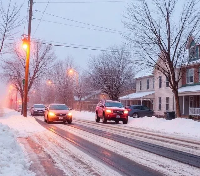
Why Travel Is a Nightmare Right Now
This storm is perfectly timed to snarl the post-Christmas exodus. Airports are already reporting hundreds of delays and cancellations:
- Major hubs like JFK, LaGuardia, Newark (EWR), Philadelphia (PHL), and Boston Logan are seeing cascading effects from de-icing queues, reduced runway capacity, and ground delays.
- Flight tracking services show widespread disruptions, with airlines activating winter weather waivers for rebooking.
- Highways—I-95, I-78, I-80, the Garden State Parkway—are treacherous, with black ice and slush making even short drives risky.
- Public transit faces delays, and power outages from any freezing rain could knock out signals and lights.
The NWS is blunt: “If travel is absolutely necessary, drive with extreme caution.” That means slow speeds, extra distance, and keeping flashlights, food, water, and blankets in your car.
The Bigger Picture: La Niña and What’s Next
This isn’t random—it’s part of NOAA’s 2025-26 winter outlook, influenced by a slowly developing La Niña. The pattern favors colder, stormier conditions in the North and East, with more frequent clippers and nor’easter threats.
And Devin won’t be the last: another fast-moving system could bring a rain-snow mix by the end of the weekend into early next week, potentially melting some snow but creating icy refreeze issues.
How to Stay Safe and Smart Today
- Avoid unnecessary travel—especially evening commutes and long drives.
- Check updates obsessively—NWS apps, FlightAware, local DOT sites.
- Prepare for outages—charge devices, have batteries and non-perishable food.
- If driving: Clear snow from your car completely, use low beams, and give plows space.
- For flights: Contact airlines early for rebooking; many are waiving fees.
Winter Storm Devin is a reminder that winter doesn’t care about your holiday schedule. It hits fast, hard, and often right when you’re least ready.
But here’s the part that matters most: storms like this pass. The snow will melt, flights will take off, and roads will clear. In the meantime, hunker down, sip something warm, and watch the flakes fall. Because even in the chaos, there’s something strangely beautiful about a white Northeast winter—especially after a few lean years.
Stay safe out there. The light at the end of this storm is Saturday’s clear skies. Until then, let the snow do its thing—we’ve got this.