


USA Weather Today: December 26, 2025 – Post-Christmas Chaos From Coast
USA Weather Today: December 26, 2025 – Post-Christmas Chaos From Coast
From record-breaking floods and mudslides in soaked California to heavy snow snarling Northeast roads, today’s U.S. weather map is a wild mix of extremes. Millions face travel nightmares, power outage risks, and dangerous conditions right after the holidays—here’s your detailed, city-by-city breakdown of what’s happening right now and what’s coming next.
December 26, 2025 – You wake up the day after Christmas expecting calm, maybe some leftover pie and quiet streets. Instead, America is dealing with a full-blown weather whiplash that feels like Mother Nature decided the holidays weren’t dramatic enough.
The West Coast is still reeling from back-to-back atmospheric river storms that turned Christmas into a soggy, dangerous mess. The Northeast and parts of the Midwest are now under winter storm warnings as heavy snow, sleet, and freezing rain move in, threatening post-holiday travel for millions. Meanwhile, the South and Southwest enjoy a relative breather with milder conditions—but don’t get too comfortable, because this winter’s La Niña pattern promises more surprises ahead.
If you’re traveling today, checking the forecast, or just trying to understand why your morning commute feels like a survival game, you’ve come to the right place. We’re diving deep into today’s U.S. weather across every major region, with specifics on temperatures, precipitation risks, active alerts, and what this means for your day. Buckle up—this is the most comprehensive look at December 26, 2025, weather you’ll find anywhere.
California: Still Underwater After Historic Holiday Deluges
California is ground zero for today’s most intense weather story. An atmospheric river-fueled storm system hammered the state on Christmas Day, continuing into today with more heavy rain, gusty winds, and mountain snow. The National Weather Service (NWS) and Weather Prediction Center have maintained Moderate to Slight Risk of Excessive Rainfall warnings across Southern California, with additional rounds of downpours possible through the day.
Downtown Los Angeles shattered records for the wettest Christmas Eve-to-Christmas Day period since 1971, receiving several inches in just 48 hours—far above the typical December total of about half an inch to one inch. Many Southern California areas saw 4–8 inches this week alone, with some spots pushing even higher.
Today, expect additional 2–5 inches of rain in coastal and valley areas, according to CBS News meteorologists. Flash flooding remains a major threat, especially in burn-scarred zones and urban areas prone to rapid runoff. Mudslides and debris flows are ongoing concerns—evacuation orders linger in multiple communities after Christmas Eve incidents, including dramatic rescues and at least two weather-related deaths reported.
In the mountains, feet of snow continue piling up in the Sierra Nevada, with heavy bands expected through Friday. This creates dangerous avalanche risks and treacherous passes—Caltrans urges avoiding non-essential travel over major routes like I-80 and Highway 50.
Northern California isn’t spared either: Marginal risks of flash flooding persist in the Bay Area and Sacramento Valley, where wind advisories add gusts up to 50–60 mph in exposed spots.
Temperatures today hover in the 50s to low 60s across much of the state—mild for winter, but the relentless rain makes it feel raw and miserable. If you’re in SoCal, stay vigilant: flood watches extend through today from the Oregon border down to Los Angeles County.
This storm series marks a dramatic reversal for a region that started the season unusually dry. It’s classic La Niña whiplash—drier early winter, then explosive wet periods—and it’s far from over.
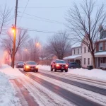
Northeast & Mid-Atlantic: Heavy Snow and Icy Mess Hits Post-Holiday Travel
If California is drowning, the Northeast is burying. A potent winter storm system is delivering the region’s first significant snowfall in years, with winter storm warnings in effect from Pennsylvania to New England. The NWS predicts accumulations of 5–12 inches in interior areas, with the highest totals in the Catskills, northeastern Pennsylvania, and parts of Upstate New York.
New York City is bracing for its biggest snowfall in more than three years—potentially 5–7 inches metro-wide, including southern Connecticut, northern New Jersey, and southeast New York. Winter storm warnings kicked in Friday afternoon and run through Saturday morning. Expect slick roads, flight delays at JFK, LaGuardia, and Newark, and hazardous conditions for anyone driving back from family gatherings.
Philadelphia and the Delaware Valley face a tricky wintry mix: 1.5–4 inches of snow and sleet, with higher amounts north toward Trenton (where odds of 4+ inches reach 63%). Freezing rain could add a quarter-inch of ice in spots, turning sidewalks into skating rinks. The NWS is blunt: “Consider delaying all travel” until the storm clears.
Farther north, moderate to heavy snow hits New England today into Saturday—perfect for winter enthusiasts but brutal for post-Christmas commuters. Boston, Hartford, and Providence could see 4–8 inches, with wind chills dropping into the teens.
Temperatures today range from the upper 20s to low 40s—cold enough to keep snow accumulating, but a brief warm-up earlier allowed the messy mix. Power outages are possible from ice, and travel delays are widespread. If you’re in the I-95 corridor, check apps obsessively—this is peak return-to-work chaos.
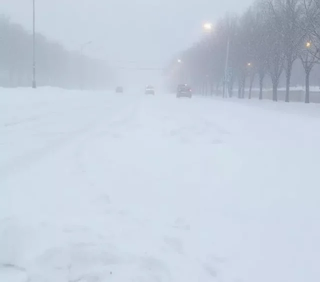
Midwest & Great Lakes: Wintry Mix and Snow Bands Take Over
The upper Midwest joins the winter party today, with a second system bringing heavy wintry precipitation from Michigan across northern Indiana and Ohio. The Great Lakes snow machine is firing: lake-effect bands could drop 6–12 inches in favored spots downwind of Lakes Michigan, Erie, and Ontario.
Michigan’s Upper Peninsula sees moderate to heavy snow, while lower Michigan deals with a dangerous mix of snow, sleet, and freezing rain. Chicago and surrounding areas face slick morning conditions after overnight precipitation—expect delays on I-90, I-94, and at O’Hare.
Temperatures hover in the teens to upper 20s across the region—classic winter bite, with wind chills making it feel single digits or below. This is the cold side of the La Niña pattern NOAA predicted: below-normal temperatures favored from the Upper Mississippi Valley westward.
South & Southeast: Milder, But Not Immune
The southern tier catches a break today. Florida, Georgia, and the Gulf Coast see highs in the 60s to 70s—Miami around 75–80°F, Dallas in the mid-60s, Atlanta near 60°F. Scattered showers possible in parts of Texas and the Southeast, but nothing severe.
This warmth aligns with NOAA’s outlook: above-normal temperatures favored across the Southeast, Gulf Coast, Texas, and Southwest. It’s a welcome contrast to the chaos up north.
Pacific Northwest & Rockies: Lingering Cold and Mountain Snow
Seattle and Portland deal with cool, damp conditions—highs in the 40s, with spotty rain. The Cascades and northern Rockies continue seeing heavy snow from the same system affecting California.
Hawaii & Alaska: Stable and Extreme
Hawaii enjoys stable, pleasant weather under an upper-level ridge—highs in the 70s to low 80s, low rain chances. Alaska, meanwhile, is bitterly cold in interior spots, with Fairbanks below zero.
Why This Weather Matters: Travel, Safety, and the Bigger Picture
With over 100 million people traveling this holiday season, today’s storms are creating historic headaches. Airports from LAX to JFK report delays, highways are treacherous, and emergency crews are stretched thin.
This pattern fits NOAA’s 2025-26 winter outlook: a slowly developing La Niña driving split conditions—cold and wet north, warmer and drier south. But short-term extremes like these atmospheric rivers and nor’easter-like systems remind us: weather doesn’t follow averages—it hits hard.
Stay safe out there. Check local NWS updates, avoid unnecessary travel in active zones, and keep emergency kits ready. The day after Christmas shouldn’t feel this intense—but in 2025, it does.
And here’s the closing thought that sticks: In a year of wild swings, today’s storms show resilience isn’t just about enduring—it’s about preparing, adapting, and remembering that even after the darkest nights (or soggiest holidays), clearer skies always find their way back. Stay warm, stay dry, and keep watching the skies. America’s weather never stays quiet for lon