


USA Braces for Arctic Invasion: Winter Storm and Bitter Cold Through New Year
USA Braces for Arctic Invasion: Winter Storm and Bitter Cold Through New Year
As Americans wrap up the holiday season and prepare for New Year’s celebrations, a dramatic shift in weather is underway across the United States. After a period of unseasonably warm temperatures in many areas, a powerful Arctic blast is plunging southward, bringing dangerous cold, heavy snow, blizzard conditions, and potential travel disruptions to millions. This week’s forecast (December 29, 2025, to January 4, 2026) features a major winter storm impacting the Midwest, Great Lakes, and Northeast, followed by reinforcing cold air that could make this one of the coldest starts to the new year in recent memory.
This detailed USA weather forecast this week breaks down regional conditions, temperature drops, precipitation expectations, potential hazards, and safety tips. Data is compiled from the National Weather Service (NWS), NOAA’s Weather Prediction Center (WPC), AccuWeather, and other reliable sources as of December 29, 2025. Stay updated as conditions can change rapidly during active winter weather.
National Overview: Arctic Invasion and Bomb Cyclone Threat
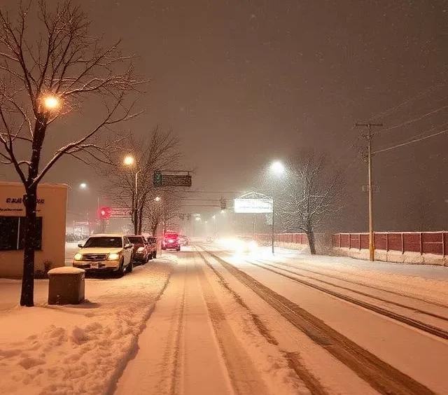
The big story this week is the arrival of Arctic air clashing with lingering warmth, fueling a potent winter storm system. Forecasters warn of a possible “bomb cyclone” – a rapidly intensifying low-pressure system – over the Great Lakes region starting late December 28 into December 30.
- Key Hazards: Heavy snow (up to 1-2 feet in some spots), blizzard conditions with whiteout visibility, strong winds (gusts 40-60 mph), freezing rain/ice in parts of the Northeast, and bitterly cold wind chills.
- Temperature Whiplash: Many areas will see highs drop 30-50°F in 24 hours. For example, parts of the Ohio Valley and Midwest could go from 60s on December 28 to 20s or lower by December 29.
- Impact: Post-holiday travel disruptions, flight cancellations/delays (thousands already reported), power outages from ice/winds, and life-threatening conditions in blizzard zones.
- New Year’s Outlook: Cold persists into January 1-4, with lake-effect snow continuing downwind of the Great Lakes. Subfreezing temps reach as far south as the Gulf Coast by mid-week.
Over 230 million Americans are expected to experience below-average temperatures this week, per FOX Weather and AccuWeather reports.
Regional Weather Breakdown This Week
Midwest and Upper Midwest (Minnesota, Wisconsin, Michigan, Illinois, Indiana, Ohio)
This region bears the brunt of the storm.
- December 29-30: Major winter storm with heavy snow (8-18 inches possible, locally higher), blizzard conditions, and winds gusting 50+ mph. Whiteouts and near-zero visibility expected. Minnesota and Wisconsin under blizzard warnings – “potentially life-threatening travel.”
- Temperatures: Highs in teens to low 20s December 29; dropping to single digits or below zero by December 30-31. Wind chills -10 to -30°F.
- January 1-4: Reinforcing Arctic air keeps temps well below normal. Lake-effect snow bands could add several more inches, especially in Michigan’s Upper Peninsula.
- Hazards: Power outages, treacherous roads, stranded vehicles. Minnesota activated National Guard for response.
Great Lakes and Northeast (New York, Pennsylvania, New England)
- December 29-30: Snow, sleet, and freezing rain mix. Heavy snow in interior/upstate areas (6-12+ inches); icing on roads in southern New England and mid-Atlantic.
- Temperatures: Highs 20s-30s early week, falling to teens by New Year’s Eve. Lows in single digits to teens.
- January 1-4: Bitter cold with lake-effect snow squalls. Highs struggle to reach 20°F in many spots; wind chills below zero.
- New York City Area: Mix of rain/snow early, transitioning to cold/dry. Highs mid-30s to low 20s by week’s end.
- Hazards: Icy roads, strong winds damaging trees/power lines.
Plains and Central US (North/South Dakota, Kansas, Missouri, Texas)
- December 29: Sharp cold front brings thunderstorms in south, transitioning to snow/winds north.
- Temperatures: Dramatic drops – e.g., Dallas from 80s December 28 to 40s December 29.
- January 1-4: Frigid air settles in; highs 20s-40s north, 40s-50s south but still below normal.
- Hazards: Blowing snow High Plains, rare late-December severe storms possible early.
Southeast and Gulf Coast
- This Week: Initial thunderstorms ahead of front December 29, then rapid cooling.
- Temperatures: Highs 60s-70s early, dropping to 40s-50s by December 30-31. Subfreezing possible north Gulf Coast nights.
- Precipitation: Rain early week, limited snow/ice north.
- New Year’s: Cooler than average, but milder than north.
West Coast and Southwest (California, Pacific Northwest, Rockies)
- This Week: Milder with ridge of high pressure. Rain/mountain snow possible New Year’s Day.
- Temperatures: Above normal – highs 50s-60s California, cooler Rockies with snow.
- Precipitation: Active pattern returns mid-late week with rain/snow.
- Overall: Best weather in the country this week compared to east.
Day-by-Day National Highlights (December 29 – January 4)
- Monday, Dec 29: Peak of winter storm – blizzards Midwest/Great Lakes, temperature plunge nationwide.
- Tuesday, Dec 30: Storm winds down east; Arctic air reinforces. Lake-effect snow ramps up.
- Wednesday, Dec 31 (New Year’s Eve): Bitter cold north/east; parties indoors recommended in affected areas.
- Thursday, Jan 1 (New Year’s Day): Cold holds; possible mountain snow West.
- Friday-Sunday, Jan 2-4: Persistent cold east; gradual moderation possible late, but below-normal temps likely continue.
Safety Tips and Travel Advice for This Week’s Weather
- Travel: Avoid unnecessary trips in storm areas. Check flights (major hubs like Chicago O’Hare, NYC airports impacted). Roads icy/slippery.
- Cold Safety: Dress in layers, limit exposure. Watch for hypothermia/frostbite. Protect pets/pipes.
- Home Prep: Stock emergency kits, generators if outages possible.
- Alerts: Monitor NWS, local forecasts. Blizzard/winter storm warnings in effect for millions.
This Arctic outbreak marks a sharp end to 2025’s mild December for many. While the South and West escape the worst, the northern half faces significant winter impacts heading into 2026.